GPS... is it worth it?

Bigshadow

Senior Master
MTS Alumni
Joined
Apr 13, 2005
Messages
4,033
Reaction score
45
Location
Saint Cloud, Florida
Selective Availability

In 1998, President Clinton directed that SA should be turned off between 2000 and 2006. Fortunately, it happened early in that range of years. The U.S. military was able to quickly develop and test their ability to selectively block accurate GPS transmissions in areas of conflict or where U.S. security was at risk. When the U.S. Air Force Space Command turned off SA last night, GPS became incredibly accurate for the entire planet.

Future plans for improving the accuracy of GPS include the launching of eighteen additional satellites that are awaiting launch or are currently in production. Additionally, two new signals will be broadcast from the satellites by 2005 to help bypass any distortion from the ionosphere.
 

OUMoose

Trying to find my place
Joined
Jan 14, 2004
Messages
1,566
Reaction score
24
/tinfoil hat on

Yeah, they need to be ultra-accurate, so when you tune-in they can train their cameras on you to peep in on exactly what you're doing, grab your phone signal out of the air to see who you're talking to, and guesstimate your intentions before you even think it...

Yeah.. that's it...

/tinfoil hat off

:D

In all seriousness, I've wanted to get one of the small handheld units for a while, but haven't been in a good financial position to get one. :) durn never-ending computer upgrades...
 

jim777

Master Black Belt
Joined
Jan 22, 2007
Messages
1,014
Reaction score
31
Location
Blackwood, New Jersey
The government might be keeping notes on where you're going, but I'm pretty sure they can't afford to hire someone to read those bazillion notes! :lol:

Anyway, We moved 160 or so miles from mid New York to South New Jersey nearly 3 years ago, and we're getting a Garmin when the tax returns come in. They make your life A LOT easier if you are driving in an area you didn't grow up in or know really well. As mentioned earlier, the recovery from wrong turns and such is a wonderful thing, especially when the box is talking to you, saying "Turn right at Whatever Street in 200 yds" and such.
My personal experience with things like Mapquest is that they usually miss a decimal point at some point in their directions, making 21 miles 2.1 miles and such as well. And, the Garmin is obviosly a lot more convenient if you are in a hurry, or have to get somewhere out of the blue. Also, with the different memory locations in them, you can get to common places (like home, or the hospital or whatever) from wherever you are NOW. Helps if you end up lost somewhere ;)
 

arnisador

Sr. Grandmaster
MTS Alumni
Joined
Aug 28, 2001
Messages
44,573
Reaction score
456
Location
Terre Haute, IN
My wife loves her TomTom. I have a TomTom built into my PDA and it has been useful at times. It has restaurant/hotel/gas station/etc. info.--we used it to find a service station when we had a tire blowout in Arkansas. If it's within your budget, I think you'll quickly come to be glad you own it.
 

Bigshadow

Senior Master
MTS Alumni
Joined
Apr 13, 2005
Messages
4,033
Reaction score
45
Location
Saint Cloud, Florida
My wife loves her TomTom. I have a TomTom built into my PDA and it has been useful at times. It has restaurant/hotel/gas station/etc. info.--we used it to find a service station when we had a tire blowout in Arkansas. If it's within your budget, I think you'll quickly come to be glad you own it.

I liked SueSue much better... :p
 

Carol

Crazy like a...
MT Mentor
Lifetime Supporting Member
MTS Alumni
Joined
Jan 16, 2006
Messages
20,311
Reaction score
541
Location
NH
Thanks, everyone!

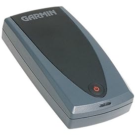
Does anyone know anything about Palm add-ons for GPS? I have a Palm T|X, and I found this on Amazon, but I don't know anything about it.


See larger image Share your own customer images

Garmin GPS10 Bluetooth-Enabled Wireless GPS Receiver with Mount and Software


I'm looking in to them for my crackberry....er....blackberry, as I mentioned here.

The unit that I mentioned may be a bit easier for carrying around as it is smaller and has a belt clip. A friend of mine has the same unit and he likes it a lot. He keeps the belt clip on it and simply clips it to the band on his visor, then clips it on his belt or bag when he leaves the car. He says the battery life is excellent.

You'll need more than just a bluetooth GPS unit. You'll need a bluetooth enabled Palm, plus mapping software that can display maps as well as interpolate GPS signals. Price on these varies, one company called Spot makes this for the Blackberry for $50.00....but Research In Motion (the company that makes the Blackberry) makes this available for certain Blackberry units at no charge. There is also a company called TeleNav that offers this service for $10.00/month. The difference between these is essentially how many points of interest are on the map. The Research In Motion software is just a map. The Spot software offers limited information. The TeleNav software offers an exhaustive amount of information about local businesses and will even read directions in to your phone for you and point you towards the lowest gas prices in town.

If you plan on using it in your car I'd also strongly recommend some sort of mount. There are a few devices that will mount a PDA in a viewable position as well as charge it from the cigarette lighter.
 
OP
Kacey

Kacey

Sr. Grandmaster
MTS Alumni
Joined
Jan 3, 2006
Messages
16,462
Reaction score
227
Location
Denver, CO
Thanks, Carol! Actually, it's not a Treo, it's a T|X... it suddenly dawned on me it would probably be a lot cheaper to adapt what I already have, especially since I have a car charger and keyboard for the Palm already.
 

Carol

Crazy like a...
MT Mentor
Lifetime Supporting Member
MTS Alumni
Joined
Jan 16, 2006
Messages
20,311
Reaction score
541
Location
NH
Thanks, Carol! Actually, it's not a Treo, it's a T|X... it suddenly dawned on me it would probably be a lot cheaper to adapt what I already have, especially since I have a car charger and keyboard for the Palm already.


Understood. That's because BigShadow has a Treo and I made that post in response to him. ;)

I think you'll really enjoy adapting your Palm to be a GPS unit. My friend has been having a great time with carrying one thats portable. Enjoy! :D
 

Ceicei

Grandmaster
MT Mentor
Joined
Apr 23, 2003
Messages
6,775
Reaction score
85
Location
Utah
I love my GPS especially when we're travelling long distance or off road. We had one installed in our car (the type that slides away hidden when not in use, looking like an ordinary stereo). It's not perfect and the directions have been known to a bit off at times, but as long as it is accurate enough in giving me the general directions (even gives updates such as weather and traffic reports), I'm very satisfied.

- Ceicei
 

Bigshadow

Senior Master
MTS Alumni
Joined
Apr 13, 2005
Messages
4,033
Reaction score
45
Location
Saint Cloud, Florida
Understood. That's because BigShadow has a Treo and I made that post in response to him. ;)

I think you'll really enjoy adapting your Palm to be a GPS unit. My friend has been having a great time with carrying one thats portable. Enjoy! :D

They make GPS add-ons for the Treo. I don't know if I would want to do that though. This is a case where I would want my GPS unit separate from my "Smart" phone :p

If I were going to get something for travelling, I would probably buy the Garmin StreetPilot. The functionality of my Treo is for things I need with me at all times. I don't need a GPS very often, maybe 6 to 10 times a year.
 

MBuzzy

Grandmaster
MTS Alumni
Joined
Aug 15, 2006
Messages
5,328
Reaction score
108
Location
West Melbourne, FL
I use a Garmin Street Pilot also and my technically challenged father just bought a newer version and he loves it.

It does help to do a bit of research on the units though. GPS is a very complex technology, so a basic understanding helps. For example, be sure that the system that you buy is only a receiver. When people talk about the "big brother" aspect, remember that it requires some sort of transmission device. The standard GPS systems are only receivers which decode the GPS signal...it is extremely difficult to track someone who is just receiving a GPS signal because they are not sending anything out - it would be almost like trying to track someone because they had their car radio on. It doesn't trasmit, it only receives.

Also be VERY VERY cautious of any company or product that charges you any kind of monthly fee. I don't know if any of these are still out there, but there used to be. The GPS Satellite constellation is ALWAYS out there. You don't have to pay a cent to use it, you just need a decoder. There were a few companies trying to capitalize on people.

Also, be aware that, as stated before, GPS is only as good as the person using it. The actual GPS technology can only tell you where you are on the earth. Your decoder will use the Satellites to determine your latitude, longiture and elevation (if you have acquired enough satellites). The mapping portion is completely proprietary, meaning that all happens within your receiver, so buy one that you're comfortable with and like the display and interface of.

I love my GPS and I can say that it has NEVER gotten me lost, when I've entered the correct destination....which I always verify using either a map or my knowledge of the area. BUT - it has taken me some CRAZY ways, sometimes a longer way, based on the direction algorithms.....so it always helps to keep a map around and have a basic knowledge of where you're going.

But no matter what, the GPS sytems on the market now are INCREDIBLE!! With the possibility of GPS II coming on line and more data being included in the signal, such as traffic info and routing based on traffic patterns, the system will only get better.
 

Bigshadow

Senior Master
MTS Alumni
Joined
Apr 13, 2005
Messages
4,033
Reaction score
45
Location
Saint Cloud, Florida
Another thing that gets people starting out with the hand held GPS devices when hiking and so forth is "Which direction am I facing"? Unless the GPS is equipped with a compass, it cannot tell you which way you are facing if you are standing still. It can only provide compass headings by calculating your vector when moving. So if you are using a handheld such as one of those ETrex types that doesn't have a built in compass, it won't be accurate until you begin moving. I believe most require you to move at a fair decent clip, depending on the device it could be from 1mph to 4 or 5mph before the direction and speed indications are accurate.
 

Latest Discussions

Top